About the Program
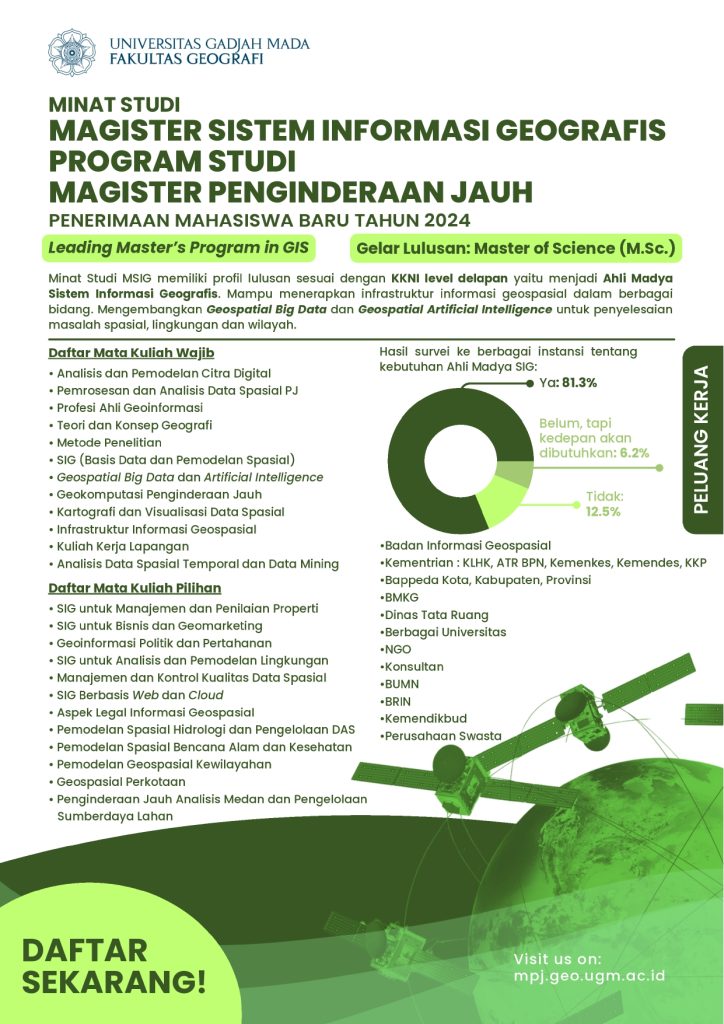
The Geographic Information Systems (GIS) Study Program is a regular program, which is part of the Remote Sensing Master’s program at Universitas Gadjah Mada. The GIS Study Program prepares graduates according to the Indonesian National Qualifications Framework (KKNI) Level 8, becoming Intermediate GIS Experts. Graduates will be able to apply geospatial information infrastructure across various fields, develop Geospatial Big Data and Geospatial Artificial Intelligence to solve spatial, environmental, and regional issues.
Objectives and Goals
In general, the goal of this program is to enhance the abilities of academics and professionals in managing geospatial information, with a focus on the application of Geographic Information Systems (GIS) and Remote Sensing (RS) in various fields, including spatial planning, risk analysis, and spatial data-based regional management. With a multidisciplinary approach, participants will be equipped with the skills to apply geospatial technology to support effective decision-making in various development and resource management contexts. Upon completing this M.Sc. program, participants will understand the principles and processes in the utilization of GIS and RS, and will be able to develop geospatial applications to address issues related to spatial planning, regional management, and other spatial analyses. Graduates are expected to be able to apply and develop GIS-based research methodologies and contribute to geospatial innovations at the local, regional, and global levels.
What Will You Learn?
The curriculum is designed to produce experts who can work synergistically with various disciplines in decision-making, problem-solving, planning, implementation, monitoring, and evaluation based on Geographic Information Systems (GIS).
List of Required Courses
– Digital Image Analysis and Modeling
– Spatial Data Processing and Analysis for Remote Sensing
– Geo-Information Professionalism
– Geography Theory and Concepts
– Research Methods
– GIS (Spatial Database and Modeling)
– Geospatial Big Data and Artificial Intelligence
– Geocomputation for Remote Sensing
– Cartography and Spatial Data Visualization
– Geospatial Information Infrastructure
– Fieldwork
– Temporal Spatial Data Analysis and Data Mining
List of Elective Courses
– GIS for Property Management and Assessment
– GIS for Business and Geomarketing
– Geo-Political and Defense Information
– GIS for Environmental Analysis and Modeling
– Spatial Data Management and Quality Control
– Web and Cloud-Based GIS
– Legal Aspects of Geospatial Information
– Spatial Modeling for Hydrology and Watershed Management
– Spatial Modeling for Natural Disasters and Health
– Regional Geospatial Modeling
– Urban Geospatial Information
– Remote Sensing for Terrain Analysis and Resource Management
—–
PROFIL PROGRAM STUDI MAGISTER PENGINDERAAN JAUH
| Program Accreditation | Accredited “Excellent”BAN-PT No. 1394/SK/BAN-PT/Akred/M/III/2021 |
| Duration of Study | 4 semesters (2 years) full-time |
| Semester Start | 1 (August), 2 (February) |
| Number of Credits | 60 credits (regular) |
| Degree Awarded | M.Sc. (Master of Science) |
Program Accreditation Certificate
—–
Vision
Vision of the Faculty of Geography:
The Faculty of Geography at UGM aims to be a world-class center of excellence in geography, which is superior and innovative to realize sustainable development, serving the interests of the nation and humanity, guided by national cultural values based on Pancasila.
Mission
Mission of the Faculty of Geography:
- Organize international-standard education to produce individuals who are devoted to God Almighty, have noble character, excel in the field of geography, and serve the interests of the nation and humanity.
- Conduct international-standard research in the field of geography.
- Engage in community service that provides solutions to environmental problems using a geographic approach.
- Establish multi-party collaboration networks at the national, regional, and global levels while enhancing good institutional governance.
—–
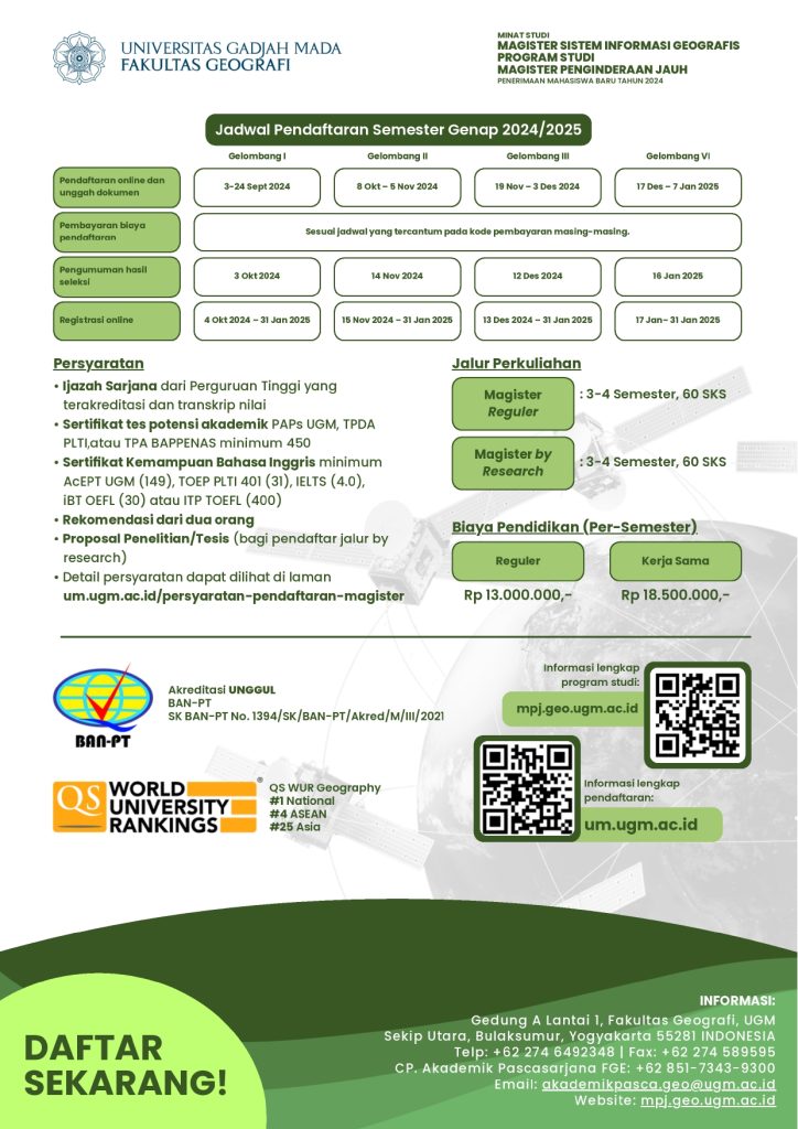
Admission Requirements
- Bachelor’s degree from an accredited university and academic transcript
- Academic potential test certificate: PAPs UGM, TPDA PLTI, or TPA BAPPENAS with a minimum score of 450
- English proficiency certificate: AcEPT UGM (149), TOEP PLTI (401), IELTS (4.0), IBT TOEFL (30), or ITP TOEFL (400)
- Two recommendation letters
- Research/Thesis Proposal (for applicants via the by-research track)
- Detailed requirements can be found on [um.ugm.ac.id](https://um.ugm.ac.id/persyaratan-pendaftaran-magister/)
—–
Study Tracks
- Regular Master’s = 3 – 4 semesters (60 credits)
- Master by research = 3 – 4 semesters (60 credits)
—–
Tuition Fees
The Single Tuition Fee (UKT) for the program is IDR 13,000,000 per semester for the regular track and IDR 18,500,000 per semester for partnership programs. This fee covers educational costs, while accommodation, research costs, books, and living expenses are borne by the sponsoring institution/self-funded. Facilities provided include air-conditioned classrooms, LCD projectors, computer labs, and field research.
—–
Flyer for the Master’s Program in Geographic Information Systems